Inside the old Salina Turda Salt Mines located in Transylvania, Romania, stands the world's largest salt mine museum. Originally established in the 17th century, the massive mines were formed completely by hand and machine rather than by using explosives. Visitors are invited to descend as far down as almost 400 feet into the Earth in order to witness the history of the trade.
Throughout the cool interior, which averages about 50-55˚F with 80% humidity, there are a variety of mines, rooms, and spaces to be explored. At almost 140 feet down, Rudolph Mine offers a 180-seat amphitheater, a carousel, ping-pong tables, basketball hoops, mini-golf, and bowling. Old machinery still stands within the underground expanse and some of it is used to lead people on tours.
Theresa Mine, at 370 feet deep, provides access to a small lake where boats can be rented and a rotating wheel allows visitors to see the stalagmites throughout the cave. Finally, the Gisela Mine (the stationary room) functions as an area for health treatments that draws upon and takes advantage of the mine's optimal climate.


Prahova Salt Mine (Slanic Prahova) is the largest salt mine in Europe that is opened to the public. At this moment, the mine is not used for industrial purposes but for touristic and medical ones. People come here all the year round to visit the impressive galleries carved in salt. Leaving aside the beauty of the place, this salt mine is also known for having a healing role in treating some respiratory infections.
The road to the salt mine is not impressive and not even the road to the core of the mountain, but once you have stepped through the gates of it, another world seems to uncover in front of your eyes. It took me over five minutes to get used to the massive galleries.
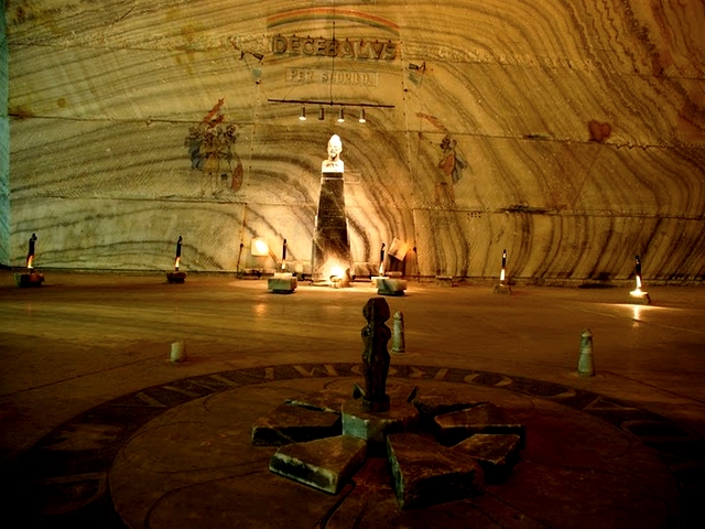
The first excavations in the Salt Mountain of Prahova are pinned by historical documents in the year 1685. The mining continued since then until 1972. The galleries are over 55 meters high, greater than the the hight of the Statue of Liberty without it’s foundation.
There are 14 rooms where you can stroll inside the mine on a surface of 78 square meters. 2,9 millions of cubic solid measure metered were excavated to reveal the great galleries.
The temperature is constant of 13 degrees celsius and the air humidity of 60%.
In one of the rooms, tourists can see a bust of Decebal the last king of the Dacians, the ancestors of the Romanian people. On the other side of the room you can also see tha bust of Traian, the roman emperor who managed to conquer the land of the Dacians. Traian and Decebal are considered to be the founders of the Romanian people.
Surrounding these busts there are some ornamental carvings that are carved in salt with Dacian and Roman motifs. Other busts in these salt galleries are of Mihai Viteazul, one of the most respected kings of Romania and one of Mihai Eminescu the most known poet of Romania.
Inside of this great mine, there are organized spaces for sportive activities and competitions. There are also leisure spaces for people who come here for therapeutic reasons. The air in the mine is exceptionally good for breathing problems and also for those who suffer from rheumatic impairment.
Salt has been known as a powerful health remedy since ancient times, especially for respiratory health and detoxification. In many ways, these two functions are the foundation of overall health.
The effectiveness of salt therapy has been measured at 85% – 90% in adults and 95-98% in children with the following health conditions:
- Bronchial asthma of varying severity
- Pneumonia after acute stage
- Chronic non-obstructive and obstructive bronchitis
- Sinusitis, pharyngitis, stuffy nose, allergic rhinitis
- Postoperative rehabilitation and recovery
- Eczema, dermatitis, and allergic dermatitis
- Psoriasis
- Hypertensive heart disease I and II-A stage
- Neuroses and neurosis conditions in diseases of internal organs.
- Cardiovascular disease
- Cough, chest congestion, sore throat
- Diseases of the endocrine system, immune system, hormonal problems
- Chronic fatigue, insomnia
- Depression
- Allergies
- Cleaning respiratory system of a smoker
- Fungus problems (prevention and treatment).

SALT MINE PRAID


We invite you to try the unique climate of salt mine Praid, another wonderful salt mine! We reccomend it for everyone, but it is no secret that this unique microclimate helps in different diseases.
The healthy people can benefit the relaxation, the beautified skin and the refreshment caused by our air composition.
Underground world
The underground visiting place is on "Level 50” which is on 120 m deep from the surface. The private transport of the people is with buses on a 1250 m long tunnel to the entrance gate of the visiting base.
Arriving to the visiting level you can enjoy all of the benefits of a small village: illumination, Wi-Fi, television, playground for the children, creative and amusement places, ecumenical chapel, Coffee Shop, 3D Cinema and a naturist drugstore. All these are in mission to make your abstention full of mirth in a pleasant and extraordinary space.
The average annually underground temperature is 16 degrees Celsius.
On the exit way from the Visiting level at “Level 60” you can find the Lookout Point “Iosif Mine”. On the same level you can participate on wine tasting programme and you can serve your meal choosing from a rich menu of our restaurant.
During a year our salt mine is visited by about 400 000 people. In summer period the number of entrances per day can be reached at 2500/3000 person.
Also in summer time after your underground visit we are waiting you on a salty water swimming pool.
Contraindications:
- pulmonary tuberculosis
- acute respiratory diseases
- hypertension (3rd phase)
- Ischemic Cardiomyopathy
- Basedow-Graves disease
- fainting neurological disorders
- neurological disorders with fainting
- claustrophobia
- advanced pregnancy
The Secrets of the Salt Mine from Praid
In the eastern part of Transylvania, on Szekler’s Land there is a region- the only one- that was named after its mineral resources: the Szekler Salt-Region. The collective name, Salt Region was first used in 1659 in the network of the following localities: Sóvárad, Sovata, Illyésmező, Parajd, Sófalva, Atyha, Siklód, Szolokma and Korond. Here, in this wonderful little region is situated the salt yard, one of the biggest places in Europe where salt can be found. The huge salt mass, which is 1.2 times 1.4 km in diameter, is slightly elliptic and it has its roots at an astonishing depth – 2.7 km.
The salt yard from Praid holds more kinds of geological, historical, mineral and therapeutic secrets. The very first secret lies in the formation of salt in Transylvania. The range of Korond-Praid-Sovata-Görgény is the trace of salt uprush (the “salt zone”), and the salt yard from Praid rises from it like an immense mushroom. The formation of the salt in Transylvania - and the pleat from Praid it includes – can be traced back to the geological age of Lower-Baden (Middle-Miocene age), 20-22 million years ago. The sediments of the following geological ages deposited on the condensed salt layers and under their pressure the salt moved to the edges of the Transylvanian Basin. The movement of the salt was furthered by the fact that its specific weight is smaller than that of its environment, and it uprushed on the line of the existing ruptures forming diaperpleats and a huge salt strata. The salt treasure of Praid hides an amount of salt that can be extracted in hundreds of years and it is one of the bottomless treasure troves in Transylvania.
In Transylvania the history of salt mining traces back to Roman times. The outcropped “salt-cuts” that had been left by the retreating Romans, were first exploited by the Avers then by the Bulgarians. One of the commander-in-chiefs of the conquering Hungarians (Töhötöm) was informed by his spies that they were “digging” salt in Transylvania. After 1003 the ships of Saint Stephan were already transporting salt on the River Maros.
The ancient community of wealth and equality of rights of the Szeklers significantly influenced their salt- mining and commerce. One of the elements of the freedom of the Szeklers (libertas) is that they can make use of their natural resources for their benefit, fact that lead to their free “salt-right” too. This is the key to the secret of the history of the salt from Praid, because during the years the Szekler’s salt mining was characterized by limitations and returning of their free salt- rights.
We can encounter the first reported written reference to the extraction of salt in the charter that Andrew II gave to the German knighthood from Barczaság in 1222. In this document he allowed them to keep six ships on the Maros and six on the Olt transporters of salt downstream and of other goods upstream. The next reference to the salt mine from the Salt Region dates from 1405, when king Sigismund of Luxembourg banned the landlords to open salt mines on their own lands. In 1463 King Mátyás reinforced the Szeklers’ right of free salt mining and commerce. The salt from Salt Region had been the common propriety of the Szeklers’ nation from the beginning and that is why every Szekler household could get salt for free, but only until 1562. This was the year when, after defeating the Szeklers’ rebellion János Zsigmond (John Sigismund) II occupied the salt mine from Praid for the royal chamber. Among the conditions of choosing prices in Transylvania there was the respect for the Szeklers’ ancient freedom and their free salt right. These princes were Gábor Báthori (1603), István Bocskai (1605), Gábor Bethlen (1613) György Rákóczi I (1631). The Szeklers gained their free salt right only for the time of the war of independence lead by Ferenc Rákóczi II.
In Praid underground mining began in 1762 when they opened the bell (“high cap”) shaped József (Joseph) mine, under the leadership of the Austrian mine officer Johann Frendl. The extracted salt was drawn to the surface by four horses in buff leather but in 1765 they could still see extractions on the surface. The year 1787 is the beginning of systematic mining, when the salt mine in Praid became the propriety of the Viennese Treasury. According to Balázs Orbán the whole region of the Szeklers and Saxons was using salt from Praid. In 1864 they opened the trapezoid shaped Parallel- mine simultaneously with widening the Nándor- mine. In 1898 they began exploiting the Erzsébet (Elisabeth)- search site in the northwestern part of the salt back.
After the First World War (1920) the Romanian polity reorganized the medieval methods of salt mining in Transylvania and Maramures. In 1945 they introduced extraction by explosions, therefore Hungarian salt mining, that had such a great tradition, became only a historic memory for good. Between 1947 and 1949 they opened the mine which keeps the memory of the great Szekler rebel György Dózsa alive, but until 1954 they were exploiting the Parallel – mine too. In 1972 they began the opening of a new mine section in the northeast of Sóhát (Salt Back) but they gave up work because of bad quality show signs.
In 1978 they established new depth levels with unique chamber - measurements in our country (12m high, 20 m wide and 200 m long) under the old mine chambers. Later, in 1991 they began working on the Telegdy- mine section in the northeast. Here the measurements of the chambers were: 16m wide and 8 m high. The quadratic stanchions have a cross-section of 14 m times 14 m.
As far as the therapeutic effect of the salt mine from Praid is concerned, here the climato- and speleotherapy began in the 1960s in the old chambers of the enlarged György Dózsa- mine. Having the results from the Polish Wieliczka as a starting-point the mine manager, Károly Telegdy and Dr. Árpád Veres physician tried the underground treatment of chronic respiratory illnesses. Since 1980 they have equipped the therapy section for visitors at the +402m level and a depth of 120m from the surface of the ground. From the entrance of the mine a 1250 m long underground bus road leads to the speleo- and climatotherapic salt chambers. The large mine chambers are provided with electricity and constant aeration. There is also a playground, an ecumenical chapel, a buffet, many seats and table tennis that make the obligatory four hours daily stay more varied. Physiotherapy lead by a specialist, badminton, renting toys for children, a little historic museum, photo exhibitions and countless works of art make this special underground world more homelike. Physical safety is ensured by a constantly present medical supervision, moral comfort is provided by the underground ecumenical chapel that was dedicated to “Nepomuki Szent János” (Saint John from Nepomuk) in 1993.
The Salt Region possesses significant scenic beauties and several geological rarities. One of these rarities is the Salt Strait and the Salt Back that has been declared a natural reservation on an area of 60 acres. The Salt Strait is in fact the valley where the Korond stream breaks through the salt range that once connected Sóhát (“Salt Back”) and the Gyilkos (Killer)- side. This way a smaller hill was detached (the Kisholló “Small Crow”). Another geological sight is the Csigadomb (“Snail Hill”) or Rakodó-hegy (“Loading Mountain”) in Korond and its aragonite rock. It lies at the southern edge of the Basin of Praid, right next to the road towards Korond. Other sights of Sóvidék (“Salt Region”) are: the fortress of Rapsonné (Mrs. Rapson), the Medvetó (Lake Bear) from Sovata, the Likaskő (Punched Stone) from Korond and numerous mineral- and salty -water springs.
The salt from Praid has been called “Szekler salt” since the XV century, that provided the Transylvanian region and its people with a name, a right (the salt right), work and living possibilities for long centuries. Last but not least it provides the taste and soul of famous Szekler and Transylvanian foods. The huge salt region from Praid has a last carefully kept secret: the magic of timelessness. The one who unravels this – will gain eternity – might be petrified.
The Praid- Basin, the so called “huge salt cellar”, lies at the encounter of the eastern edge of the Transylvanian Basin and the Görgényi Mountains and it constitutes a separate region–unit within the borders of a geographic region called“Sóvidék”.
The Transylvanian Basin was formed as a result of the continuous sinking that began at the end of the cretaceous age and the beginning of the Paleocene age while the neighboring Carpathian mountain- chain rose. A shallow continental inland sea was formed in that depression. It wasn’t connected with the surrounding oceans and seas.
At the edge of the Transylvanian Basin we can find Paleocene sediments, which lean towards the inside of the basin; further inside we can find the diapire corrugations, where the deep salt-blocks have broken through the younger sedimentary strata. In the center of the basin there is a region of wide cyclical corrugations – the so called “domes” – that have porous rocks. In the Superior Baden -, Sarmatic and Lower Pannonian ages significant natural gas - yards came about in these rocks.
The salt-belt is the most characteristic structural and morphological region of Sóvidék. The salt-belt, that lies along theSzovata-Praid-Korond line represents the edge of the volcanic plain of Mezőhavas(1100-1150m) that was suddenly broken. It lies in the 30km long depression between Bekecs (1079m) and Siklódkő (1025m).
The Praid Basin can be considered a deepened (erosion) basin if we take into consideration its origin. The diaper –tectonic phenomena had an important role in the formation of the basin. This way the appearance of the Sóháta from Praid (the salt rucks covered the younger strata of the Neogene strata) on the surface modified not only the accidence and water system of the basin, but its biographical features too. With its prominence between Harom-tető (710) and Malomhegy (623m) at the encounter of Kis-Küküllő and the Stream Korond, Sóháta caused morphological and hydrographic changes. The acne-like prominence of salt created a barrier in the dropping of the Stream Korond. The Kis-Küküllő, being bigger and more energetic, could keep up with the prominence of salt and it could gradually deepen its erosion valley. Probably it had taken along the Stream Korond too for a while through that terrace that lies between Sóháta and Köves-vápa (550m)- to the east.
In a wider sense the Praid Basin lies round the hill Sóhát, embracing Praid and the two places called Sófalva. The shape of the basin reminds of a stretched triangle with its peak pointing towards Korond in the south, and to the northwest it reaches Szováta Basin. The Praid Basin is divided from the Transylvanian Basin by the range of Szálas Firtos (1062m), Fiasmál (983m), Küsmödkő (991m) and Siklódkő (1025m). The Sóhát (Salt Back), its local name being “Sóháttya”, is in fact holding the most valuable treasure of the Praid Basin and the Szekler Sóvidék (Salt Region): the great salt yard, that has a depth of 2,7 – 3km. The horizontal salt stratum has an elliptical shape, its diameters being 1,2 and 1,4km. Vertically it looks like a huge abnormal mushroom. It is due to say that the huge salt block is one of the largest diaper rucks in Europe and its reserve could provide the continent with salt for more than a houndred years.
From the point of view of stratum studies we can say that the salt block, during its ascendance, broke through the Mio-Pliocene sediments and came to the surface in the erosion window of the Praid Basin. According to the studies of its structure and strata we can say that the salt block was once down deep under the younger strata. Its root is still 2700-3000m deep and its shape is elliptical. It the above mentioned sediments all the four classical strata of the Baden stratum are present: the lowest one is a tufa stratum originating in Dézs and globigerinae, then the upper salt and gypsum layers. On these there are the slate strata that contain radiolaria and clayey margates. Finally there is the stratum of margates that contain Spirialis. The “cap-rock” of the salt is made up of margates and slate, which contain foreign rocks too like: limestone, quartzite, gneiss, talc-clay, crystal limestone and other contemporary rocks of Tries, Jurassic and Cretan ages.
The material of the salt yard in Praid is the “halite” a halogenated mineral, that crystallizes in a rectangular system but sometimes it can have an octahedral shape. The salt in Praid has tiny crystalline granules, but it contains contamination too. After breaking it is uneven and shelly, its flaw shows a perfect square along the weakness lines. Its colour varies between milky white and dark gray and black according to the amount of contamination, Its natural colour is white, but for example the salt that contains cyanide varies between light pink and purple red. The primary macro-crystals have the most complete lattice system and they are the most transparent. The coordination number of the natrium and chlorine elements of the salt crystal is 6, so in the lattice system each Na ion is surrounded by 6 chloride ions.
The “halite” is spread in bulks (initially only the solid mineral was named halite), it is white, it has glass light and it feels oily when touching, it coloures flames into yellow. It can join other types of rocks too in series like: silvine, gypsum, dolomite, anhydrite etc., and its hardness is 2,5 according to the Mohs categorization. The mineral rock that is made up of halite is named halitite.
The compounds of the halite from Praid is: 94-98% NaCl and 2-6% clay minerals (the insoluble part). There are other secondary minerals too like: kieserite, kainite, polihalite, quartz, pirite and iron hydroxides. Kieserite, kainite and quartz can be found in the material of the halit in granes, and clay minerals can be found only in pieces smaller than 0,4mm. Talc slate and pirite represent only a smaller amount. The salt from Praid, opposite the salt from the Old Romania, contains only little amounts of Ca sulfate.
One of the most important features of the salt yard in Praid is that it contains other rocks between the salt layers like: crystal slate, quartzite, limestone, clay slate), fact that influences its quality. Salt appears in dense strata, white and dark grey layers vary rhythmically, the lines of different strata can be seen on the walls of the salt chambers.
The Transylvanian salt- and within that the salt from Praid- originates in the Lower Baden geological age (the Middle Miocene age of the new third age) 20-22 million years ago. At this time the shallow inland sea was blocked and separated from the ancient Tethys, and as a result of strong evaporation the created salt strata settled in the sinking basin. The sediments settled on this salt layer in the following geological ages and due to their pressure the salt moved towards the Transylvanian Basin just like a slowly flowing, thick liquid. Here, in the region of the diaper rucks, the salt layers became solid reacting to great forces and they headed towards the surface in huge blocks of salt. They couldn’t break up to the surface everywhere, they got stuck at different depths and they are still present in the center of salt belts as kryptodiapers.
In the area of salt mountains we can notice a vivid salt karst phenomena: in the salty areas there are smaller and bigger funnels filled with clay that are similar with the phenomena of limestone areas: dolines, water absorbing blocks, hilite. A number of dolines and blocks are still continuously forming as results of the falling in of some hollows created by underground waters. The bigger funnels are the traces of irregular mining, in certain cases the Roman salt mining in amphitheatre shape or the newer “scamp-mines” (shapeless salt holes), where the people were stealing the salt from in the times when it was banned.
The natural salt generates the final karstic phenomenon, because of the very rapid dissolving process, helped by the fissures, diaclasis and stratification planes, all access ways for infiltration water. Dissolving and the advance of the water will generate saturation, after that only the dynamic action will operate, resulted from the flow energy. Gradually, the water will leave the upper surfaces and will penetrate the underground circulation paths. This is how the exokarst from the beginning of the process is transformed in endokarst phenomenon. The wide of the cover formation in Corund area is under 6 m, and in these conditions, a part of the pluvial water arrived on the salty stratum, then by dissolving and erosion, circulation paths appeared for the infiltration water.
The characteristic flora of Sóvidék has formed very close to the salt rocks. It can also be noticed that as a result of the great amount of evaporation, especially in the summer salt flowers cover the flat parts at it presents a bleak picture of Sohata and Sószoros (Salt Strait). In Sóhomlok, Nádasfő, Fűrészoldal and between the bare cliffs the plants are not totally extinct. To this kind of places characteristic plants are: the thick, red or green Salicornea herbacea, Aster tripolium,Spergularia salina, Salsola soda, Artemisia salina, Plantago maritima, Statice gmelini (salt flower).
60 hacters of Sószoros (Salt Canyon) and Sóhát were made geological reservations in 1995 (according to law number 13/1995 made by The County Council). The “Salt strait” is in fact a valley created by the Stream Korond and it lies on the southwest part of the Sóhát (Salt Back). Here the stream cut through the mountain and it flows down surrounded by white salt rocks until its encounter with the Stream Kis-Küküllő. Those salt rocks can be seen in Salt Strait that are called salt rocks from Praid, and they were a touristic sight in the last century too. Here the earth holds the salt-fortune of a whole sea region, the salted water springs are sweating salt and even the dust on the roads is mixed with salt.
The climate of the Praid Basin is moderate continental, a bit colder than that of the Transylvanian Basin. The average temperature is 8.2 C˚, in the summer 19-20C˚ and in winter –8, -10C˚. The number of days that are warmer than 25C˚ is less than 80, the temperature fluctuation in a year is 60C˚. The warmest month is July, the amount of rainfall is quite considerable: in rainy years 800-1000mm/year, in dry years 600-700/year. The humidity of the air is relatively high, 75-80%.


Niciun comentariu:
Trimiteți un comentariu